

| » | » | » | » |
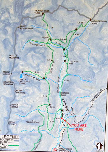
It was Monday, September 2nd (Labor Day), 2013, when Suzy and I drove over to the Colorado River Trailhead on the West side of the Continental Divide in the Never Summer Range, which lines the upper western boundary of Rocky Mountain National Park. Our destination was Lake of the Clouds via the Red Mountain Trail, to the Grand Ditch Road, and then up the Lake of the Clouds Trail - roughly a 13 mile round trip. The map below is posted at the trailhead.

Thirty minutes up the trail (about a mile), we walked up on a doe and her fawn. While they did not move far off the trail as we passed, I struggled to get a good shot through the brush. Luckily, curiosity got the best of the fawn and it stopped just long enough for this picture.

About 2.5 miles up the trail now, at 9:15 AM, we were caught completely by surprise when this Pine Marten popped out of the forest onto the trail right in front of us. Neither Suzy nor I had ever seen one before, so we kept a cautious distance; although, we were pretty close from the start. As it climbed a few feet up a tree to check us out, I took pictures. This really made our day!


It was 9:45 AM when we finally came up on the Grand Ditch Road. On easy level ground now, we had hiked for about 15 minutes, give or take a few, when we started noticing raspberries on the side of the road. We just couldn’t resist stopping to have a fresh fruit breakfast, so Suzy pulled out a sandwich bag and we started filling it up. They were "really" good!

We were about a mile up the Lake of the Clouds trail now, maybe a quarter mile from the boulder field below Lake of the Clouds (11:18 AM), when we crossed this beautiful little meadow with a tiny pond. The whole meadow was somewhat soggy though, so it’s probably not the kind of place you would want to set up a picnic.

When we came out at the boulder field, the sound of rushing water immediately caught my attention. Looking west, I pointed out the waterfall to Suzy. She looked, pulled out the map, and said she thought the lake was right above it. Wow! That caught me by surprise. I was not expecting the final approach to be this steep, and I couldn’t see any trace of the trail from where we stood.

After crossing the boulder field, Suzy was feeling a little sluggish and just wasn't up for the scramble up to the lake. I couldn't turn around without seeing it though, so I started up while Suzy started back down. We had lost the trail entering the boulder field, but I was fairly sure it went up the scree slope right of the waterfall. I am not a fan of scree slopes though, and not knowing how loose it was, I chose to ascent directly up the right side of the waterfall (3rd to 4th class). It was steeper, but the rock looked a little more secure - I hoped anyway. Suzy, looking back and seeing the route I was taking, decided she better stick around in case I fell. I took this shot of the waterfall on my way up, showing how it disappeared under the boulders in sections.

At 12:15 PM, I got my first look at Lake of the Clouds. It was bigger than I had expected. I would have hiked around it with more time, but I needed to get back down and catch up to Suzy.

I wasn't feeling real good about trying to down-climb the waterfall route, so having found the "real" trail, I decided to try descending the scree slope. Surprisingly, the trail was much better than I expected, and I got back down to the boulder field in just 15 minutes. Before going further, I turned around to get one more shot of the headwaters of the Big Dutch Creek. Halfway into the boulder field, I found Suzy.

Back on the Grand Ditch Road again, in the heat of the day and feeling a little dehydrated, the raspberries were looking even better than they had in the morning. We refilled the sandwich bag and managed to save some of it to put on breakfast cereal at home in the morning. I took this shot of Suzy showing off our harvest at 1:55 PM.

It was 4:00 PM when we arrive back at the trailhead. Per the GPS, we hiked 13.61 miles in 8 hours and 2 minutes, reached a height of 11,453 feet above sea level, and had a total elevation gain of 2,653 feet. We relaxed for about 30 minutes with sandwiches, sport drinks, and a beer before heading home. The downside of this trip was that in two months, we had hiked 128 miles of rough mountain trails, and my Achilles Tendons were now badly torn. Crossing the boulder field twice this day had me limping for months. I can only hope that the tendons will heal over the winter, because there’s a lot we want to do in 2014.
This hike had an unbelievable variety of mushrooms and fungi scattered along the trail, and I got shots of as much of it as I felt I had time for. While I think I’ve identified a couple, any help would be appreciated.
National Park Service - Climbing and Mountaineering in Rocky Mountain National Park
Rocky Mountain National Park: The High Peaks
U.S. National Parks Net - Rocky Mountain National Park Hiking Guide